


Autrans : Pas de l'Ours

j.pont
User
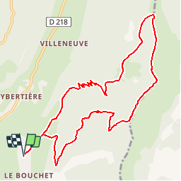

Length
11.6 km

Max alt
1714 m

Uphill gradient
631 m
Km-Effort
20 km

Min alt
1096 m

Downhill gradient
631 m
Boucle
Yes
Creation date :
2015-05-18 00:00:00.0
Updated on :
2015-05-18 00:00:00.0
4h15
Difficulty : Difficult

FREE GPS app for hiking
 SityTrail
IGN / Geographical institutes
SityTrail Plus
The world is yours!
About
Trail Walking of 11.6 km to be discovered at Auvergne-Rhône-Alpes, Isère, Autrans-Méaudre en Vercors. This trail is proposed by j.pont.
Photos


Positioning
Country:
France
Region :
Auvergne-Rhône-Alpes
Department/Province :
Isère
Municipality :
Autrans-Méaudre en Vercors
Location:
Autrans
Start:(Dec)
Start:(UTM)
701174 ; 5005442 (31T) N.
Comments
Très jolie rando et Pour le retour, depuis le parking de la Molière, il y a un sentier balisé qui nous ramène à Autrans par la forêt. Très sympa